
A small group of RGG members did this walk in September 2008. It is described here so that others may enjoy it.
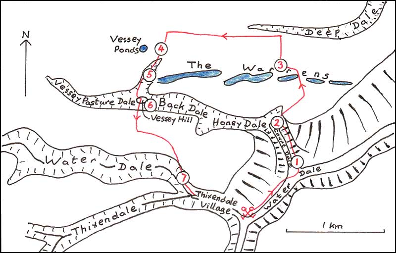
Start from the Cross Keys pub in Thixendale and take the field path NE along Water Dale, crossing the entrance to Court Dale and climb up to a small coppice.
Stop 1
From here the views show some typical features of dry valleys. The slopes of Water Dale are markedly asymmetric, the NW-facing slope being much steeper. There is no simple explanation for this. It is not due to differences in rock type as everything is chalk and it does not appear to be related to aspect since other dry valleys parallel to Water Dale have symmetrical sides. There is an abrupt change in slope onto the flat floor of the valley which here lies at about 120m OD and close to the base of the chalk. The underlying Kimmeridge Clay would explain the presence of standing water on the valley floor after wet weather, and, of course the name of the valley.
Across Water Dale to the SE an old pit is visible on the hillside. Note that this exposes no chalk in situ but only chalk rubble. This rubbly layer covers much of the Wolds and results from repeated freeze and thaw in the cold climate of the last glaciation. Then the ground would have been permanently frozen except for a poorly vegetated surface layer which would have thawed in the summer and flowed downhill, a process termed solifluction. This may leave solifluction terraces on the sides of the valley. Indeed if you look back the way you have come, there is a terrace towards the bottom of the NW side of Water Dale.
The melting snows of early summer would have produced a lot of surface water which was unable to drain through the frozen subsoil. The flat floor of the valley would have been occupied by a stream of braided channels flowing through drifts of chalk rubble.
Continue NNW along the narrow path until, at the northern end of Court Dale you have a view W along Honey Dale.
Stop 2
Honey Dale divides and the larger fork, Back Dale, narrows and appears partly blocked by rounded protuberances of its southern slope. The reason for this will become more apparent later in the walk.
Continue along the path which turns sharply right and climbs steadily onto the Wolds plateau at about 190m OD where it meets a track and proceeds NNW down into a hollow where it crosses “The Warrens”, climbs again and then before it turns sharply N
Stop 3
Something of the Warrens can be seen from this point. They are elongated hollows running E-W en echelon. The hollow immediately to the west has been cultivated, the one to the south is overgrown with trees. Unlike the dry valleys they have no outlet and represent solution hollows or dolines. Such features are uncommon on the chalk lands.
Follow the path north to the edge of the upper part of Deep Dale, here quite a shallow valley. Turn west along the track over gently rising ground of the plateau to the highest part of the walk at 216m. Then turn south alongside a linear earthwork and look out for a small area of marshy ground with course vegetation in the arable field to the west.
Stop 4
This patch of wet ground is known as “Vessey ponds”. Large quantities of flint artefacts have been found around the ponds and it is thought that in prehistoric times they provided a water supply on the otherwise dry Wolds plateau.
Continue south down a short tributary valley which truncates the western end of the Warrens.
Stop 5
Here there is a prominent chalk scree, to what extent man-made is uncertain. It gives a good illustration of the nature of the Wolds surface during the last glaciation. Looking down the valley its mouth is partly blocked by the small rounded Vessey hill.
Continue down to Vessey Pasture Dale and climb around onto Vessey Hill, slightly off the path.
Stop 6
This small isolated hill is a good example of a deep rotational land slip. The steep slope to the south has failed and a slice has slipped down onto the valley floor partly blocking it. Looking to the east along Back Dale similar slips can be seen. The eastern end of these were viewed from Stop 2 earlier in the walk. Such landslips would have been very active under permafrost conditions during the last glaciation.
From Vessey Hill a steep climb south brings you back onto the Wolds plateau. There is a chalk pit to the north of the path, partly rubbish-filled but still showing a chalk face with pale flints. From the long descent which returns you to Thixendale village there are good views to the west.
Stop 7
Notice the contrast in the form of the two dry valleys to the west. Water Dale has a sinuous course with interlocking spurs but Thixendale is quite straight. I offer no explanation but these differences certainly add to the beauty and diversity of the Wolds landscape.