We met on the cliff top at Thornwick Bay. The view over the bay showed gently dipping chalk with some of the bedding planes picked out by tabular flints which Pete explained may be due to the flint being first deposited as burrow fills and then often extending to form flint nodules or tabular flints. Some other prominent bedding planes were marked by thin marl layers. The flint and marl horizons in the chalk can be traced over great distances and can be used to establish a detailed stratigraphy. The sea had exploited vertical joints in the chalk, widening them to form caves and eventually stacks. The upper half of the cliffs was formed of boulder clay giving it a very different appearance.
Descending to the shore we were introduced to the Ravendale Flint lying about 2 metres below the Triple Tabular flints. Using the handout of the stratigraphy (Rawson and Wright 2000 Fig.42) we were able to locate the Deepdale Flint and the intervening marl bands and to follow these horizons around the bay and to note the Ferruginous Flint which was seen to form the roof of the arch at Thornwick Nab. Fossils are not very abundant in this chalk . However some pieces of a large rugose Inoceramid (similar to I. lamarcki stumckei) were found on detached pieces of chalk on the foreshore.
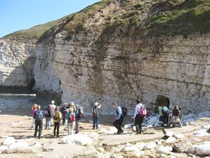
Returning to the cliff top we drove to Flamborough Head lighthouse and descended down the numerous steps to Selwick Bay, pausing just above the beach to view the structure of the intertidal wave cut platform. This was largely obscured by seaweed although dipping beds and a synclinal core could be recognised. After landing on the beach we turned our attention to the cliff section.
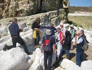
To the north and south the chalk was very gently dipping but in the middle of the bay it was much faulted and locally folded and brecciated. Pete explained that his disturbance was due to an underlying fault within the Howardian–Flamborough fault Belt and posed the question whether the overall movement was down to the north or to the south. A marker horizon which would settle this was provided by the highest flint band which divides the flint-bearing Burnam Chalk from the flintless Flamborough Chalk. This flint band was detected quite high in the cliff on the south side of the bay but was near the cliff base on the north side, in spite of a general southerly dip. Hence we could conclude that the overall movement was down to the north by about 20m.
Calcite veins and calcite lined cavities were seen in the brecciated chalk at the south end of the deformed zone. Most of the obvious faults were normal with a small throw and dipping either north or south forming a fan structure (listric fan) in the middle of the bay and a criss-cross (conjugate) pattern in the northern part of the deformed zone. The details of this quite complicated structure were not pursued.
We walked into Monk hole to see how marine erosion had formed caves and arches.